No products in the cart.

Paddle surfing Lake Bled
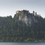
199,00 €Bled Castle over the hill photo
669,00 €Bled Castle Slovenia
199,00 €
Lake Bled’s romantic view
669,00 €
Geography:
Bled is located on the southern foot of the Karawanks mountain range near the border with Austria, about 50 km (31 mi) northwest of the national capital of Ljubljana.
South of Lake Bled are the densely forested Pokljuka and Jelovica plateaus and the easternmost parts of the Julian Alps, where the Sava Bohinjka river and the parallel Bohinj Railway lead to the Bohinj basin, Lake Bohinj, and the Triglav massif.
A number of rises (Grad 599 m, Straža 646 m, Kozarca 558 m, Osojnica 756 m, and Ravnica 729 m) separate the localities of Bled around the lake, the former villages of Grad, Mlino, Rečica, Zagorice, and Želeče.
The lake is 2.12 kilometres (1.32 mi) long and 0.5 to 1 kilometre (0.31 to 0.62 mi) wide.
In summer, the surface water reaches 25 °C (77 °F) and retains a temperature up to 18 °C (64 °F) until autumn.
As such, it is suitable for swimming. During colder winters, the entire lake freezes and can be used for ice skating; the island can then be reached on foot.
There is a thermal spring (23 °C or 73 °F) near the lake, next to the Bled Fault. Its water is used in indoor pools in two hotels.
History:
A settlement area since Mesolithic times, the present-day locality probably arose about 600 during the Slavic settlement of the Eastern Alps.
After the Slavic principality of Carantania was conquered by Frankish forces in 788, the area came under Bavarian influence.